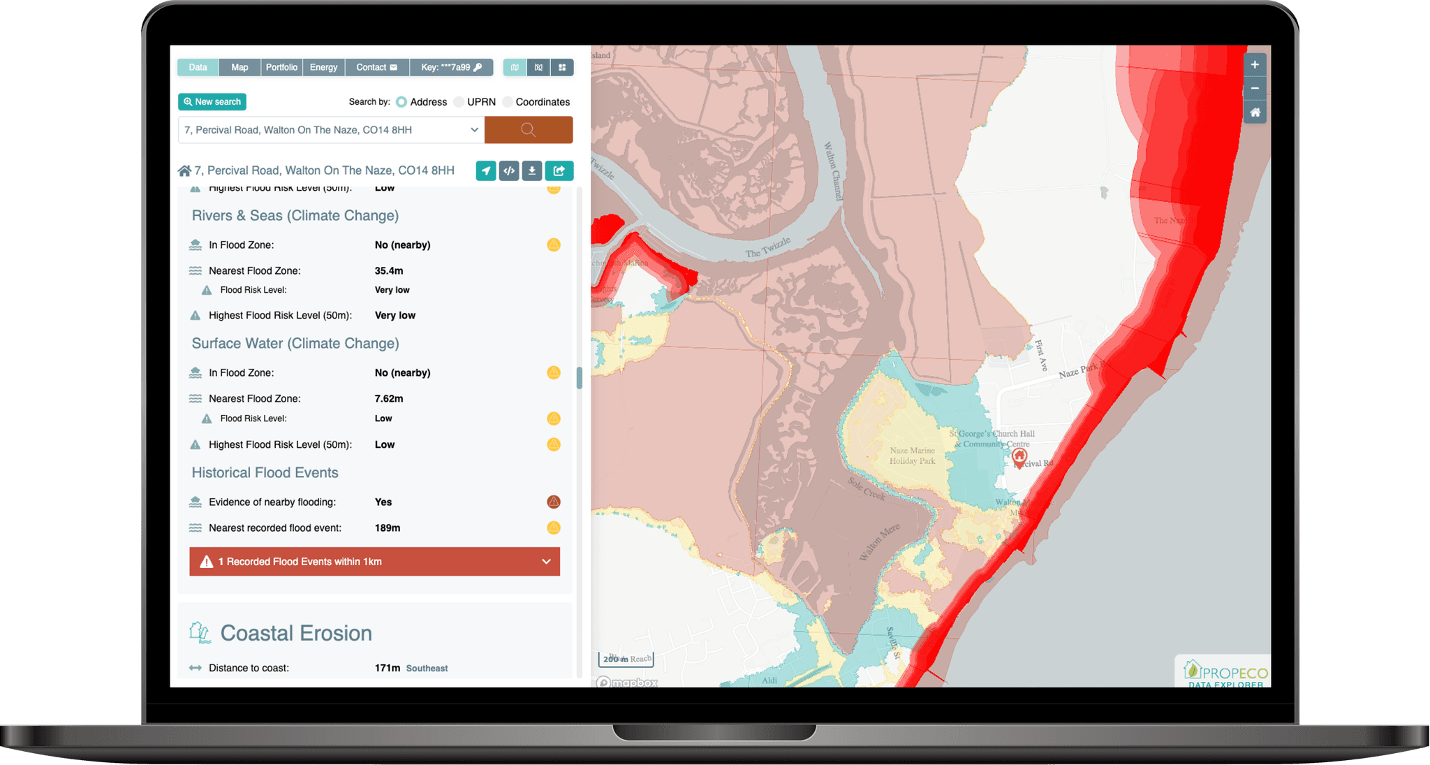
Energy Model Product Shot

Climate Risk API

Generate comprehensive assessments of current & future climate risks at UK properties or locations.

Quickly assess exposure to flood risk, coastal erosion, subsidence, wildfire, extreme weather and water stress.

Climate change is creating new and increasingly complex risks for UK properties. Rising temperatures, changing rainfall patterns, more frequent extreme weather events and rising sea levels are altering the environmental hazards that buildings and their surrounding locations face.

These risks extend well beyond flooding. Properties may also be exposed to coastal erosion, wildfire, subsidence and water stress, with the nature and severity of these hazards varying significantly between locations. Importantly, a property that faces relatively limited environmental risks today may experience very different conditions in the decades ahead.

Understanding these risks can be challenging. Relevant information is often spread across multiple datasets and providers, making it difficult and time-consuming to develop a comprehensive picture of a property's climate vulnerability. For lenders, insurers, investors and property professionals, this can create uncertainty when assessing long-term exposure, resilience and potential financial implications.

As climate-related risks become increasingly important in property decisions, access to reliable, consistent and forward-looking assessments is essential. Bringing together information on multiple hazards enables organisations to identify potential vulnerabilities, compare properties and make better-informed decisions about investment, lending, insurance and adaptation.

PropEco's Climate Risk API brings together current and future climate and environmental risk information in a single, easy-to-integrate service. Covering flood risk, coastal erosion, wildfire, subsidence, water stress and climate conditions, it enables organisations to assess individual properties quickly and efficiently, reducing the time, cost and complexity of understanding climate-related risks.

The PropEco Climate Risk API provides data & analysis relating to the current and future climate risk at UK properties and locations. Each assessment includes:

Flood risk

Risk of flooding from rivers, seas and surface water.

Flood risk with climate change

Risk of flooding across future climate change scenarios.
Subsidence

Current and future exposure to subsidence risk factors.

Climate Change Projections

Projected changes to temperature and weather patterns under multiple climate change scenarios.

Wildfire Risk

Proximity and location of major wildfires.
Coastal Erosion

Proximity and location of affected areas.

Water Stress

Current and future water supply issues.

Built on authoritative data

Our assessments combine data from leading public bodies and specialist organisations with PropEco's own analysis and models.


Environment Agency
Scottish Environment Protection Agency
Natural Resources Wales
British Geological Survey
Met Office
NASA
Ordnance Survey

Data providers are acknowledged for attribution purposes. Their inclusion does not imply endorsement of PropEco or its services.

Access hundreds of data points with just four lines of code and a coordinate.
{ "location": { "uprn": 34076006, "x_coord": 526131, "y_coord": 176355, "latitude": 51.47211, "longitude": -0.1853445 }, "flood": { "england": { "rivers_and_seas": { "in_flood_risk_zone": true, "annual_flood_risk": 0.001, "flood_risk_description": "Very low", "nearest_flood_risk_zone": { "max_annual_flood_risk": 0.001, "min_annual_flood_risk": null, "flood_risk_description": "Very low", "distance": 0, "nearest_point": null }, "highest_risk_flood_zone_within_50m": { "max_annual_flood_risk": 0.001, "min_annual_flood_risk": null, "flood_risk_description": "Very low", "distance": 0, "nearest_point": null } }, "rivers_and_seas_climate_change": { "in_flood_risk_zone": true, "annual_flood_risk": 0.001, "flood_risk_description": "Very low", "nearest_flood_risk_zone": { "max_annual_flood_risk": 0.001, "min_annual_flood_risk": null, "flood_risk_description": "Very low", "distance": 0, "nearest_point": null }, "highest_risk_flood_zone_within_50m": { "max_annual_flood_risk": 0.001, "min_annual_flood_risk": null, "flood_risk_description": "Very low", "distance": 0, "nearest_point": null } }, "surface_water": { "in_flood_risk_zone": true, "annual_flood_risk": 0.033, "flood_risk_description": "Medium", "nearest_flood_risk_zone": { "max_annual_flood_risk": 0.033, "min_annual_flood_risk": 0.01, "flood_risk_description": "Medium", "distance": 0, "nearest_point": null }, "highest_risk_flood_zone_within_50m": { "max_annual_flood_risk": null, "min_annual_flood_risk": 0.033, "flood_risk_description": "High", "distance": 1, "nearest_point": { "x_coord": 526132, "y_coord": 176355, "latitude": 51.47210972630409, "longitude": -0.1853303316314699 } } }, "surface_water_climate_change": { "in_flood_risk_zone": true, "annual_flood_risk": 0.033, "flood_risk_description": "High", "nearest_flood_risk_zone": { "max_annual_flood_risk": null, "min_annual_flood_risk": 0.033, "flood_risk_description": "High", "distance": 0, "nearest_point": null }, "highest_risk_flood_zone_within_50m": { "max_annual_flood_risk": null, "min_annual_flood_risk": 0.033, "flood_risk_description": "High", "distance": 0, "nearest_point": null } } }, "scotland": null, "wales": null }, "climate": { "annual_hot_days": { "baseline_hot_days": 2.4, "upper_recent_hot_days": 8.6, "upper_recent_hot_days_change": 6.199999999999999, "upper_recent_hot_days_change_relative": 2.583333333333333, "lower_recent_hot_days": 4.6, "lower_recent_hot_days_change": 2.1999999999999997, "lower_recent_hot_days_change_relative": 0.9166666666666666, "upper_hot_days": 42.1, "upper_hot_days_change": 39.7, "upper_hot_days_change_relative": 16.541666666666668, "lower_hot_days": 7.6, "lower_hot_days_change": 5.2, "lower_hot_days_change_relative": 2.166666666666667 }, "maximum_temperature": { "baseline_maximum_temperature": 30.93, "upper_recent_maximum_temperature": 33.95, "upper_recent_maximum_temperature_change": 3.020000000000003, "upper_recent_maximum_temperature_change_relative": 0.09763983187843528, "lower_recent_maximum_temperature": 31.64, "lower_recent_maximum_temperature_change": 0.7100000000000009, "lower_recent_maximum_temperature_change_relative": 0.02295505981247982, "upper_maximum_temperature": 39.08, "upper_maximum_temperature_change": 8.15, "upper_maximum_temperature_change_relative": 0.2634982217911413, "lower_maximum_temperature": 31.88, "lower_maximum_temperature_change": 0.95, "lower_maximum_temperature_change_relative": 0.03071451665050113 }, "summer_precipitation": { "baseline_summer_precipitation": 1.53, "upper_recent_summer_precipitation": 1.67, "upper_recent_summer_precipitation_change": 0.1399999999999999, "upper_recent_summer_precipitation_change_relative": 0.09150326797385616, "lower_recent_summer_precipitation": 1.34, "lower_recent_summer_precipitation_change": -0.18999999999999995, "lower_recent_summer_precipitation_change_relative": -0.12418300653594767, "upper_summer_precipitation": 1.245267, "upper_summer_precipitation_change": -0.28473299999999996, "upper_summer_precipitation_change_relative": -0.1861, "lower_summer_precipitation": 1.320237, "lower_summer_precipitation_change": -0.20976300000000003, "lower_summer_precipitation_change_relative": -0.1371 }, "winter_precipitation": { "baseline_winter_precipitation": 1.65, "upper_recent_winter_precipitation": 1.97, "upper_recent_winter_precipitation_change": 0.32000000000000006, "upper_recent_winter_precipitation_change_relative": 0.193939393939394, "lower_recent_winter_precipitation": 1.64, "lower_recent_winter_precipitation_change": -0.010000000000000007, "lower_recent_winter_precipitation_change_relative": -0.006060606060606067, "upper_winter_precipitation": 2.080485, "upper_winter_precipitation_change": 0.4304849999999999, "upper_winter_precipitation_change_relative": 0.2609, "lower_winter_precipitation": 1.4754299999999998, "lower_winter_precipitation_change": -0.17457, "lower_winter_precipitation_change_relative": -0.1058 } }, "subsidence": { "collapsible_deposits": { "class": 1, "legend": "Low", "advisory": "Areas of localised significant rating" }, "compressible_ground": { "class": 1, "legend": "Low", "advisory": "Areas of localised significant rating." }, "landslides": { "class": 1, "legend": "Low", "advisory": "Areas of localised significant rating." }, "running_sand": { "class": 1, "legend": "Low", "advisory": null }, "shrink_swell": { "class": 3, "legend": "Significant", "advisory": "Areas of localised significant rating." }, "soluble_rocks": { "class": 1, "legend": "Low", "advisory": null }, "shrink_swell_2030_medium_emissions": { "class": "Possible", "legend": "It is possible that climate change will affect clay shrink-swell susceptibility and change the likelihood of ground movement, which causes subsidence." }, "shrink_swell_2050_medium_emissions": { "class": "Probable", "legend": "It is probable that climate change will affect clay shrink-swell susceptibility and change the likelihood of ground movement, which causes subsidence." }, "shrink_swell_2070_high_emissions": { "class": "Probable", "legend": "It is probable that climate change will affect clay shrink-swell susceptibility and change the likelihood of ground movement, which causes subsidence." }, "shrink_swell_2030_high_emissions": { "class": "Probable", "legend": "It is probable that climate change will affect clay shrink-swell susceptibility and change the likelihood of ground movement, which causes subsidence." }, "shrink_swell_2080_medium_emissions": { "class": "Probable", "legend": "It is probable that climate change will affect clay shrink-swell susceptibility and change the likelihood of ground movement, which causes subsidence." } }, "coastal_erosion": { "has_nearby_erosion_zones": false, "nearest_zone_distance": null, "intersects_erosion_zone": false, "england": { "projections": { "medium_term": [], "long_term": [] }, "ground_instability": { "zone": null, "future_recession": null } }, "wales": { "projections": { "short_term": [], "medium_term": [], "long_term": [] } }, "scotland": { "projections": { "medium_term": [], "long_term": [] } }, "nearest_coastal_point": { "distance": 30724.878493703334, "azimuth_degrees": 90.49706750391849, "x_coord": 556854.722267165, "y_coord": 176088.450749494, "latitude": 51.462038937084245, "longitude": 0.25656558408344476 } }, "wildfire": { "wildfire_burned_areas": { "overlaps_burned_area": false, "nearest_burned_area": null, "events": [] } }, "water_stress": { "water_resource_zone_code": "TWSLND", "water_resource_zone_name": "London", "water_company": "Thames Water", "forecasts": [ { "period_start": 2026, "period_end": 2027, "baseline": { "deployable_output": 1958.0206, "water_available": 1801.2506, "distribution_input": 1941.22683, "target_headroom": 179.44, "available_headroom": -139.97623, "supply_demand_balance": -319.41623, "supply_demand_balance_pct": -16.45434861 }, "final_plan": { "deployable_output": 2315.463792, "water_available": 2140.306019, "distribution_input": 1892.488929, "target_headroom": 179.44, "available_headroom": 247.8170909, "supply_demand_balance": 68.37709092, "supply_demand_balance_pct": 3.61307746 }, "climate_change": { "deployable_output_change": -43.4593, "consumption": 1.687356156 } }, { "period_start": 2030, "period_end": 2031, "baseline": { "deployable_output": 1940.2567, "water_available": 1774.9367, "distribution_input": 2004.97493, "target_headroom": 191.3, "available_headroom": -230.03823, "supply_demand_balance": -421.33823, "supply_demand_balance_pct": -21.01463832 }, "final_plan": { "deployable_output": 2268.4657, "water_available": 2103.1457, "distribution_input": 1859.795423, "target_headroom": 191.3, "available_headroom": 243.3502773, "supply_demand_balance": 52.0502773, "supply_demand_balance_pct": 2.798709829 }, "climate_change": { "deployable_output_change": -56.5635, "consumption": 3.163931261 } }, { "period_start": 2040, "period_end": 2041, "baseline": { "deployable_output": 1886.708389, "water_available": 1698.388389, "distribution_input": 2128.15583, "target_headroom": 123.43, "available_headroom": -429.7674414, "supply_demand_balance": -553.1974414, "supply_demand_balance_pct": -25.99421685 }, "final_plan": { "deployable_output": 2025.917889, "water_available": 1887.597889, "distribution_input": 1730.297278, "target_headroom": 123.43, "available_headroom": 157.3006108, "supply_demand_balance": 33.87061076, "supply_demand_balance_pct": 1.957502401 }, "climate_change": { "deployable_output_change": -107.0841114, "consumption": 7.19625125 } }, { "period_start": 2050, "period_end": 2051, "baseline": { "deployable_output": 1635.241284, "water_available": 1446.921284, "distribution_input": 2195.13983, "target_headroom": 95.22, "available_headroom": -748.2185455, "supply_demand_balance": -843.4385455, "supply_demand_balance_pct": -38.42299857 }, "final_plan": { "deployable_output": 1790.418684, "water_available": 1726.3273, "distribution_input": 1623.372557, "target_headroom": 95.22, "available_headroom": 102.9547435, "supply_demand_balance": 7.734743464, "supply_demand_balance_pct": 0.476461391 }, "climate_change": { "deployable_output_change": -128.0809155, "consumption": 11.41274327 } }, { "period_start": 2060, "period_end": 2061, "baseline": { "deployable_output": 1614.24438, "water_available": 1425.92438, "distribution_input": 2196.86683, "target_headroom": 97.74, "available_headroom": -770.9424497, "supply_demand_balance": -868.6824497, "supply_demand_balance_pct": -39.54188018 }, "final_plan": { "deployable_output": 1769.42178, "water_available": 1718.4057, "distribution_input": 1612.943919, "target_headroom": 97.74, "available_headroom": 105.4617805, "supply_demand_balance": 7.721780536, "supply_demand_balance_pct": 0.478738315 }, "climate_change": { "deployable_output_change": -149.0778197, "consumption": 15.36303779 } }, { "period_start": 2070, "period_end": 2071, "baseline": { "deployable_output": 1593.247876, "water_available": 1404.927876, "distribution_input": 2195.74883, "target_headroom": 103.39, "available_headroom": -790.8209539, "supply_demand_balance": -894.2109539, "supply_demand_balance_pct": -40.72464672 }, "final_plan": { "deployable_output": 1757.225276, "water_available": 1710.5838, "distribution_input": 1599.459604, "target_headroom": 103.39, "available_headroom": 111.1241955, "supply_demand_balance": 7.734195514, "supply_demand_balance_pct": 0.483550537 }, "climate_change": { "deployable_output_change": -170.0743239, "consumption": 19.29012113 } }, { "period_start": 2080, "period_end": 2081, "baseline": { "deployable_output": null, "water_available": null, "distribution_input": null, "target_headroom": null, "available_headroom": null, "supply_demand_balance": null, "supply_demand_balance_pct": null }, "final_plan": { "deployable_output": null, "water_available": null, "distribution_input": null, "target_headroom": null, "available_headroom": null, "supply_demand_balance": null, "supply_demand_balance_pct": null }, "climate_change": { "deployable_output_change": null, "consumption": null } }, { "period_start": 2090, "period_end": 2091, "baseline": { "deployable_output": null, "water_available": null, "distribution_input": null, "target_headroom": null, "available_headroom": null, "supply_demand_balance": null, "supply_demand_balance_pct": null }, "final_plan": { "deployable_output": null, "water_available": null, "distribution_input": null, "target_headroom": null, "available_headroom": null, "supply_demand_balance": null, "supply_demand_balance_pct": null }, "climate_change": { "deployable_output_change": null, "consumption": null } } ] } }

API pricing

Flexible subscriptions for accessing PropEco property and location intelligence through our APIs.

Exploration

£29/mo

2,500 credits / month

  • Up to 250 standard API calls
  • Access to all API endpoints

Start-up

£69/mo

7,500 credits / month

  • Up to 750 standard API calls
  • Access to all API endpoints
Most Popular

Scale-up

£149/mo

30,000 credits / month

  • Up to 3,000 standard API calls
  • Access to all API endpoints

Professional

£249/mo

60,000 credits / month

  • Up to 6,000 standard API calls
  • Access to all API endpoints

Prices exclude VAT. Usage is based on credits. Standard API calls consume 10 credits, while some premium endpoints consume additional credits.

Need higher volumes, bulk data access or a bespoke solution? View enterprise options

Maps

Easily integrate detailed, up-to-date map layers into existing websites or applications.

Data explorer map example 1
Data explorer map example 2
Data explorer map example 3
Data explorer map example 1
Data explorer map example 2
Data explorer map example 3

Data Explorer

Instantly access property-specific data, maps and tools through the PropEco Data Explorer.

data explorer mock up

Have questions about this API? Get in touch to discuss data coverage, integration, pricing or your specific requirements.

You can also contact us at info@propeco.io or connect with us on LinkedIn here.